


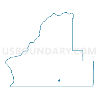
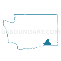
CP 2 Voting District, Walla Walla County, Washington
About
Outline

Summary
| Unique Area Identifier | 689914 |
| Name | CP 2 Voting District |
| County | Walla Walla County |
| State | Washington |
| Area (square miles) | 0.59 |
| Land Area (square miles) | 0.59 |
| Water Area (square miles) | 0.00 |
| % of Land Area | 100.00 |
| % of Water Area | 0.00 |
| Latitude of the Internal Point | 46.04694550 |
| Longtitude of the Internal Point | -118.39731560 |
Maps

Graphs
Select a template below for downloading or customizing gragh for CP 2 Voting District, Walla Walla County, Washington


Neighbors
Neighoring Voting District (by Name) Neighboring Voting District on the Map
- Blalock Voting District, Walla Walla County, WA
- CP 1 Voting District, Walla Walla County, WA
- CP 3 Voting District, Walla Walla County, WA
- CP 4 Voting District, Walla Walla County, WA
- Garrison Voting District, Walla Walla County, WA
- Ritz Voting District, Walla Walla County, WA
- Twin Grove Voting District, Walla Walla County, WA